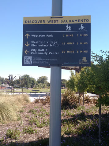
Safe Routes to School Wayfinding
Building on Safe Routes to School programs at West Sacramento Schools, we wanted to highlight the other fun places that you like to walk and bike to around town. Once you have tested out a route, be sure to come back and sumbit feedback on the routes. Your feedback will help inform more permanent signage in the future.
Scroll down to see where signs are located!
Select Your Zone
Instructions for finding your route:
Step 1: Identify your zone on the sign and match it to a zone below.
Step 2: Click the Discover button to view the zone map of places to go.
Step 3: Click the Rate this Route button to provide feedback on your trip and to be entered to win a $50 gift card! Your feedback helps us understand how to improve signage.
Discover All Routes
WHAT IS WAYFINDING?
Wayfinding are directional signs and artwork that help people get where they are going. The wayfinding we're using tells people how long of a walk or bike ride it is to their favorite places, like parks, libraries, community centers, and restaurants. Sometimes we don't realize that the places we like to go are really not that far away!
ABOUT THE PROGRAM
These signs are part of a temporary pilot program to connect West Sacramento residents to nearby destinations. Destinations were identified with the help of community survery distributed earlier this year. The signs will remain up throughout the summer. Feedback gathered from this program will help inform more permanent wayfinding signage in West Sacramento.
Do you have more feedback about the signs or an idea on how to improve the system? We want to hear from you.
If you have feedback on a specific route, scroll up to select the zone and fill out the survey. If you have a general question or comment, you can contact us here. You will be enterted to win a $50 gift card!


